Place-Based Approach

Forward SGF champions a shift in the City’s planning focus from use to design with an emphasis on creating quality places to experience through a place-based approach (discussed in Chapter 5: Land Use and Development).

The City has entered into a contract with a consulting firm to facilitate and draft an update to the Zoning and Development Code, which will provide the City with the regulatory framework essential to implement many of the recommendations outlined in the Comprehensive Plan that will impact expansion of uses and quality of place enhancements for (re)development projects.

The City has initiated several of the recommended text amendments to bridge implementation of the new Comprehensive Plan, while the new Zoning Code is being developed.
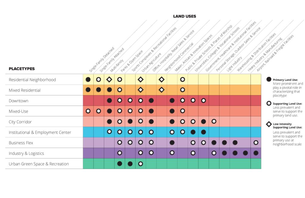
Traditionally, land planning forecasts appropriate development types and patterns based almost exclusively on use. Forward SGF instead defines neighborhoods, districts, and corridors based on desired character, scale, form, function, and use. This place-based approach to planning and development focuses on defining what mix of uses function together to collectively establish an identifiable and memorable place.


Forward SGF’s place-based approach uses placetypes to create a development palette that defines all areas of Springfield and its growth areas. It will serve as a framework for the stewardship of existing areas needing protection and reinvestment, and for managing desired growth and development across the community. To view an interactive map of the placetypes, click here and turn on the placetypes layer.
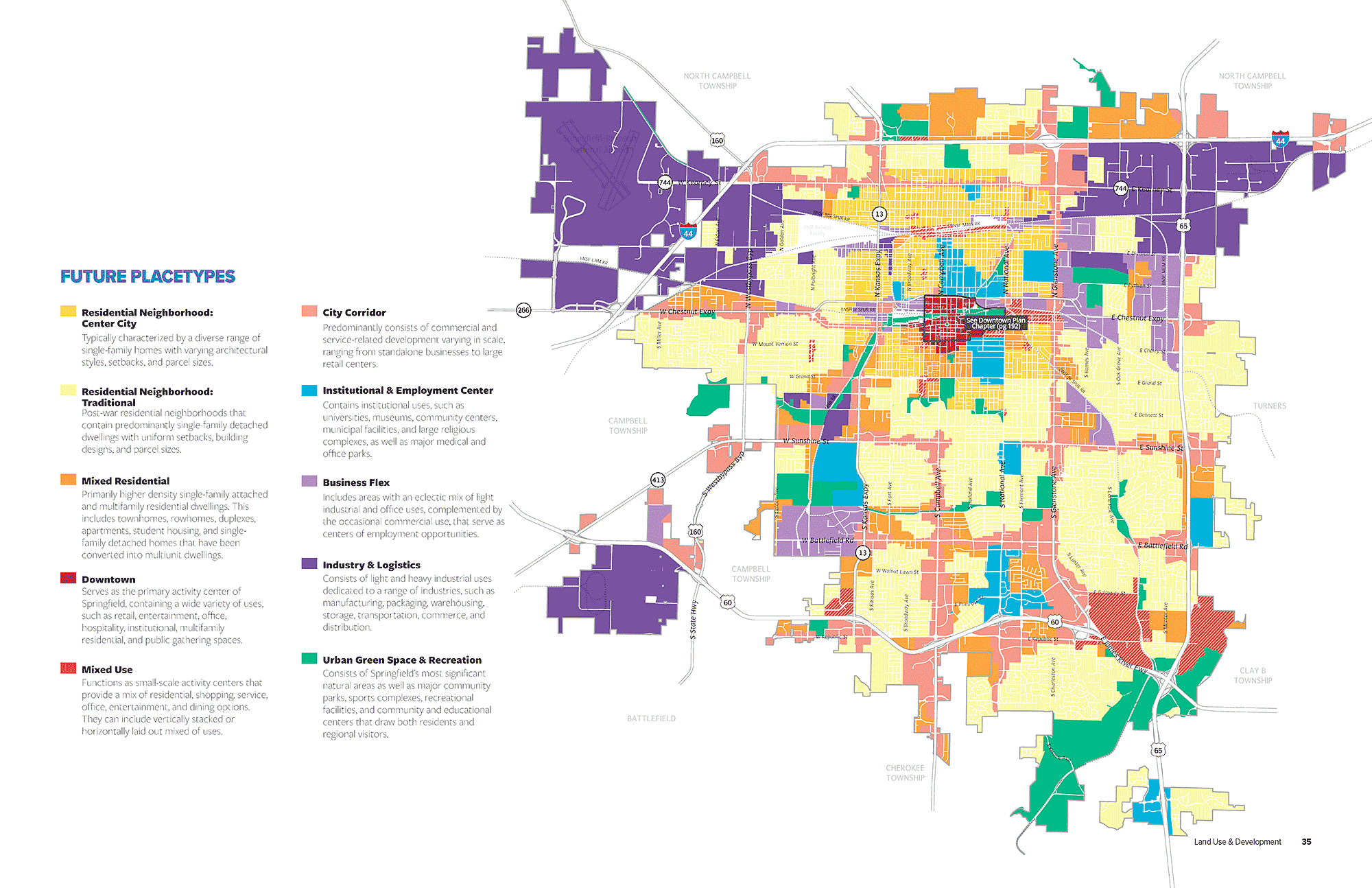

Nine Springfield placetypes are identified, which will evolve over time and be strengthened through community engagement, neighborhood planning, public and private investment, and strategic partnerships. These placetypes will require maintaining and improving existing places, as well as developing new places over time. Each placetype includes a description of its overall character, including typical uses, key physical features, mobility considerations, and other elements that define each district.

Center City Neighborhoods are Springfield’s oldest residential neighborhoods, dating to before WWII. They are typically characterized by a diverse range of single-family homes with varying architectural styles, setbacks, compact and shared spaces and parcel sizes. Center City neighborhoods historically had small scale neighborhood supporting retail services provided at key intersection, streetcar routes, and neighborhood centers. These building types and commercial uses were integrated into the neighborhood fabric. Most Center City Neighborhoods follow a gridded block pattern with alleys, tree-lined streets, and a well-connected sidewalk network that allows residents to walk to nearby neighborhood amenities. Due to their compact form and proximity to urban centers, these neighborhoods are places where residents should reasonably be able to walk, bike, or ride transit to meet some of their educational, employment, shopping, and recreational needs. Center City Neighborhoods are also integrated with key cultural and institutional uses, such as schools and places of worship that serve surrounding residents.

Traditional Neighborhoods are comprised of post-war residential neighborhoods that contain predominantly single-family detached dwellings with uniform setbacks, building designs, and parcel sizes, that are separated from dissimilar uses by distinct zoning boundaries and buffer yards. Housing in Traditional Neighborhoods range from bungalows to expansive ranch-style homes constructed with a variety of materials and methods. Neighborhood parks, schools, and churches are dispersed throughout to serve nearby residents. These neighborhoods can follow a gridded block pattern or curvilinear streets and are well connected internally with sidewalks and trails. Traditional Neighborhoods tend to be expansive, isolating residents from services and resources on the edges, often beyond walking distance.

The Mixed Residential placetype contains primarily higher density single-family attached and multi-family residential dwellings. This includes townhomes, rowhomes, duplexes, apartments, student housing, and single-family detached homes that have been converted into multiunit dwellings. Residential uses are supported by key cultural and institutional centers, such as schools and places of worship. Housing for university and college students, young professionals looking for housing close to work, and seniors desiring to downsize are prioritized within this placetype. Encouraging investment to enhance existing properties as well as attracting new high quality development with attention to scale and building design is a key focus to ensure desirable character within the placetype.

The Downtown placetype serves as the primary activity center of Springfield, containing a wide variety of uses, such as retail, entertainment, office, institutional, multi-family residential, and public gathering spaces. The pedestrian environment is accentuated with ample streetscaping elements, offering a unique and attractive place to live, work, shop, dine, and socialize. This placetype contains the densest areas within the City with higher building heights encouraged. Vertical mixed-use buildings with residential or office located above active ground floor uses, oriented to streets and sidewalks, are the predominant development type. Some supporting stand-alone commercial or multifamily uses also exist. Integrated multi-family housing increases foot-traffic in the area, helping to create a lively, thriving environment.

Areas within the Mixed Use placetype function as activity centers that provide a mix of residential, shopping, services, office, entertainment, and dining options. These centers can also host small to moderate sized manufacturing, maker spaces, artisan shops, galleries, and music venues that contribute to innovation or themed entertainment districts. Depending on the existing character of the area and the vision identified, mixed use areas, districts, corridors, and developments can take on a very prescriptive or wide range of uses as well as design requirements.

The City Corridor placetype predominantly consists of commercial and service related development varying in scale, ranging from standalone businesses to large retail centers. City Corridors are also key locations to support and encourage multi-family developments that rely on proximity to retail, commercial services, and employment centers. Each of these use groups are best located along major roadways with high volumes of traffic. This placetype is not only highly accessible by car, but also by walking, biking, and transit. City Corridors provide a wide range of shopping, service, entertainment, and employment destinations for both residents and visitors. Common uses within the placetype include chain restaurants, gas stations, hotels, national retailers, movie theaters, smaller offices, and a variety of support services.

The Institutional and Employment Center placetype contains a variety of major medical and office parks, and a collection of institutional and employer campuses. Large campuses are supported by small commercial sales and service business, and a mix of community-orientated amenities. Student housing is also a common component. In the case of universities or colleges, along with mixed housing types located along the fringes and transitional areas, providing housing near major employers is important. Areas within this placetype act as centers of culture, education, and business development, while providing numerous employment opportunities for residents of Springfield and others from the region. As Institutional and Employment Centers provide vital jobs and services to the entire metro area, multimodal accessibility and public transit connectivity are key components of this placetype. Underutilized parcels are assembled and redeveloped into more intense supporting uses or higher density housing developments where appropriate, to increase activity within the center. Planning for Institutional and Employment Center placetype focuses on infrastructure and corridor improvements to facilitate traffic flow, multimodal connectivity, and streetscaping improvements, needed to enhance the character and connectivity of key corridors. As these centers of activity receive high volumes of visitors and commuters into the City, it is essential that the quality of development and visual appeal of the corridors remain attractive and representative of the City’s desired image.

The Business Flex placetype includes areas with an eclectic mix of light industrial, office, storage, warehouse, and distribution centers, complemented by the occasional commercial sales and services. Business Flex areas are located on secondary roadways, where good street connectivity and access to major roadways and distribution routes can be easily accessed. Located in expanded areas adjacent to higher, more intense industrial uses and city corridors, Business Flex provide support services, sales, service, and supply of goods to consumers and contractors, where high visibility road frontage is not a priority. Planning for this placetype focuses on ensuring Business Flex operations have sufficient land available to expand and grow, while not dominating corridors where high visibility, retail frontage is prioritized.

The Industry and Logistics placetype consists of heavy and moderately intense manufacturing, distribution uses, and a range of operations that rely on proximity to the City’s airport, interstate, and rail facilities. Businesses and operations that supplement and provide logistical support for larger operations are also accommodated, such as those with significant outdoor storage and parking and circulation lots for trucking and freight. This placetype is critical to Springfield’s economy and employment base and is enhanced as such with improved access management, clear wayfinding, and gateway features. Planning for this placetype involves a highly collaborative effort to preserve and help procure sufficient real estate for industrial parks, airport, rail operations, and expansion needs.

The Urban Green space and Recreation placetype consists of Springfield’s most significant natural areas as well as major community parks and recreational facilities that draw both residents and regional visitors. Areas identified for this placetype include environmentally sensitive areas, such as riparian zones adjacent to waterways, floodplain and flood prone areas, as well as forested areas that provide recreational access to trails and parks. Preservation and improvement of urban green space and recreation areas are an essential factor in making Springfield a desirable place to live. They allow for active and passive recreation, healthy lifestyles, beautification of the community through greenery, and natural habitats with ecological value. Passive open spaces within the Urban Green space and Recreation placetype are preserved and enhanced as Springfield continues to grow, including the City’s urban forest. Existing park facilities are enhanced, while opportunities for new parks are pursued with growth and to address underserved residential areas. Urban green space and recreation areas are stand-alone destinations based on significant land area, water, or related natural features, whereas neighborhood parks are supporting uses in the Residential Neighborhood and Mixed Residential Placetype.

The City will soon begin work to develop and codes to support the creation of new street typologies as alternatives to the Functional Street Classification system. These typologies will align with the placetypes, outlined in the Comprehensive Plan. Street typologies will support alternative street designs more fitting of the adjacent land and traffic patterns and multi-modal transportation goals of the area served.

The six street typologies identified in Forward SGF:

Mixed-Use Streets are two-lane roadways designed for commercial and residential land use patterns that increase quality of place by incorporating green infrastructure, walkable and transit-friendly elements, and traffic calming that prioritizes pedestrian safety and experience.

Commercial Connector Streets serve commercial and light manufacturing land use patterns. While traditionally designed for an auto-oriented environment with high speeds and high traffic volumes, future designs can increase quality of place by incorporating green infrastructure, walkable and transit-friendly elements, and traffic calming.

Neighborhood Connectors are typically two-lane streets with on-street parking, sidewalks, and are designed to provide access to a diverse range of housing types and local neighborhood supporting services. These streets provide character enhancing quality of place, promoting safety, a walkable environment and sense of community.

Local neighborhood streets are two-lane roads with on-street parking and sidewalks, designed to provide access to residential neighborhood homes and supporting services. Streets are enhanced to spark new investment, increase neighborhood pride and identity, and promote safety, walkability, and quality of place.

Urban Parkways are divided expressways and arterials that are largely auto-oriented but have been transformed into landscaped thoroughfares designed to improve and beautify the City while efficiently moving higher volumes of traffic at moderate to high speeds. Routes selected for parkway classification would be limited and would require support and cooperative agreements with the Missouri Department of Transportation.

Shared Streets are transformed to increase quality of place by prioritizing pedestrian use and experience over that of vehicles with extremely low traffic volumes and speeds.

Grant Avenue Parkway Community Engagement Event – February 2021

Chapter 5 – Land Use & Development

  • Land Use Planning Framework – Placetypes

Chapter 6 – Growth & Annexation

  • Managed Growth – Growth Areas and Future Placetypes

Chapter 7 – Housing & Neighborhoods

  • Goal 1.  Support the Creation of Complete Neighborhoods
    • (1.1) Create and Expand Neighborhood Amenities
    • (1.3) Beautify Neighborhoods
  • Goal 2.  Diversify Housing Choices
    • (2.1) Support Context-Sensitive Higher Density Development
    • (2.2) Encourage Creative Housing Solutions
    • (2.3) Create Attainable, Market-rate Housing
  • Goal 3.  Revitalize Springfield’s Neighborhoods
    • (3.1) Reinvest in Existing Homes
    • (3.4) Provide Healthy, Accessible Housing

Chapter 8 – Economic Development

  • Goal 1.  Redefine Springfield’s Narrative as a Major Competitor and Leader in the Regional Market
    • (1.3) Update the Code
  • Goal 2. Clearly Define and Strategically Plan for New Industrial and Business Park Areas
    • (2.2) Leverage Key Development Sites
    • (2.4) Enhance the Character of Industrial Districts
  • Goal 3. Promote Reinvestment in Springfield’s Commercial Corridors and Key Gateways
    • (3.1) Prioritize Improvement Corridors
    • (3.2) Increase Accessibility of Commercial Corridors
  • Goal 4.  Support Business Growth and Reinvestment in Neighborhood Commercial Hubs and Downtown
    • (4.1) Support Local Commercial Hubs
    • (4.3) Promote Entrepreneurial Stewardship

Chapter 9 – Transportation & Mobility

  • Goal 3. Integrate Transportation and Land Use to Support Mobility and Placemaking
    • (3.1) Adopt Street Design Checklists and Update Guidelines
    • (3.2) Adopt the Street Typology Overlay
    • (3.3) Enhance Community Character and Placemaking

Chapter 10 – Infrastructure & Community

  • Goal 3. Develop Infrastructure and Community Facilities in a Sustainable Manner
    • (3.1) Apply Sustainable Development Practices
    • (3.2) Identify, Promote and Protect Natural Infrastructure
    • (3.3) Improve Water Quality

Chapter 11 – Parks, Greenways, & Natural Resources

  • Goal 2. Equitably Integrate Quality Public Spaces Throughout the City
    • (2.4) Ensure a Connection to Nature in New Development and Redevelopment
  • Goal 4. Ensure Sustainable Growth and Environmental Stewardship by Conserving the City’s Natural Resources, while Fostering a Sense of Community Responsibility and Pride through Education and Immersive Experiences.
    • (4.1) Increase Environmental Stewardship and Protections.
    • (4.2) Promote Sustainable Development
    • (4.3) Become a Leader in Sustainability in Southwest Missouri
    • (4.6) Preserve and Enhance the Urban Forest
    • (4.7) Leverage Natural Features for Public Spaces

Chapter 12 – Subarea Plans

  • Glenstone Avenue Subarea Plan – Framework recommendations
  • Trafficway Street Subarea Plan – Framework recommendations
  • Chestnut Expressway Subarea Plan – Framework recommendations
  • Lake Springfield Subarea Plan – Framework recommendations
  • Boonville Avenue Subarea Plan – Framework recommendations

Chapter 13 – Downtown Plan

  • Goal 4: Attract high quality investments into Downtown that enhances quality of place and economic vitality

Chapter 13 – Commercial Street Plan

  • Goal 1.  Guide the growth of, and investment into, a thriving mixed-use district.
    • (1.1) Cultivate an eclectic, thriving mix of local businesses within the district
    • (1.2) Bring more residents to the Street and its surroundings
    • (1.3) Bring additional workers to the street and its surroundings
  • Goal 4.  Build on Commercial Street’s maker ethos and strength in artisan manufacturing district
    • (4.2) Ensure land use codes allow for flexible maker spaces and artisan manufacturing uses throughout the district.

Chapter 15 – Implementation

  • Land Use and Development
    • Orchestrate and recognize the Next Steps once the Comprehensive Plan is adopted Growth and Neighborhood Integration Continue Planning
    • Growth and Neighborhood Integration
    • Continue Planning
  • Integrate Land Use, Placetypes, and Zoning
    • Create a strategy for updating the City Land Development Regulations and Zoning Map based on the Placemaking approach
  • Implementation through regulation
    • Implementation of interim amendments

Partners