Corridor Improvements

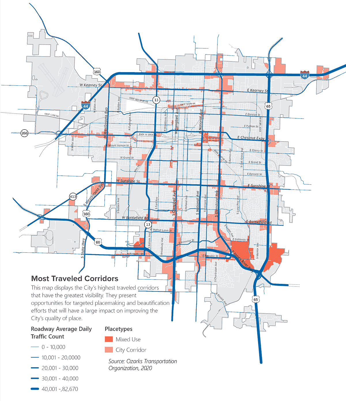
Reinvestment in and the beautification of Springfield’s commercial corridors was highlighted as a top initiative by the community during the public engagement process. The highest traveled corridors should be targeted for public and private improvements, as they would have significant impact in improving the City’s physical image, catalyzing attractive development, and building community pride.

Prioritizing Corridor Improvements

Corridors under the City’s jurisdiction should be prioritized to leverage the City’s greater control and flexibility in improvements to enhance quality of place. As some corridors are under the jurisdiction of the Missouri Department of Transportation (MoDOT) and Greene County Highway Department, future enhancements should be coordinated closely with respective transportation agencies.

Key corridors include:

  • Battlefield Street
  • Campbell Avenue
  • Chestnut Expressway
  • Glenstone Avenue
  • Kansas Expressway
  • National Avenue
  • Sunshine Street

It is important to note that investments should be balanced across the City to improve the overall image and vitality of Springfield in an equitable manner— this includes corridors facing the greatest disinvestment and those that are traveled the most, as well as those most used by GPS and navigation programs, such as Chestnut Expressway, Trafficway Street, or Glenstone Avenue. Development assistance should be provided to private developers and property owners in key redevelopment areas facing disinvestment in the City Corridor placetype to help offset cost of infrastructure improvements.
Subarea Plans

The City has entered a contract with a consulting firm to facilitate and draft an update to the Zoning and Development Code, which will provide the City with the regulatory framework essential to implement many of the recommendations outlined in the Comprehensive Plan that will impact expansion of uses and quality of place enhancements for (re)development projects located along key corridors in the city.

The City will begin the process of identifying new infrastructure projects along major corridors that will be funded over the course of the next 5 years. When possible, the corridor projects included will have a greater emphasis on quality of place. Forward SGF identified five areas of focus that exhibit significant potential for change, seen on the map below.
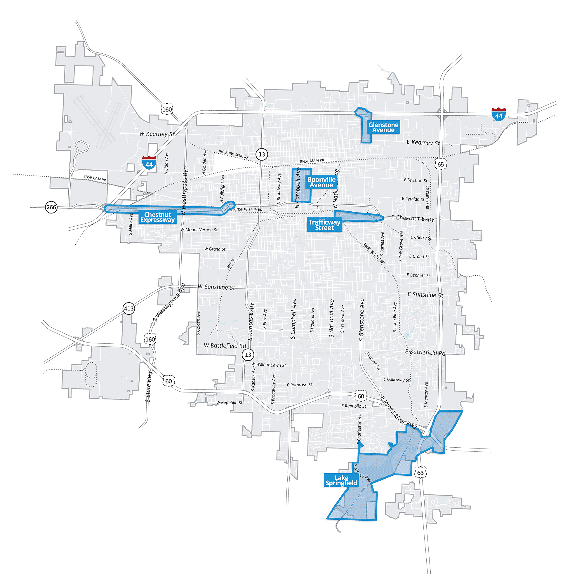
As a primary travel route from Interstate 44 and the location of many of Springfield’s hotels, the Glenstone Avenue corridor near I-44 is a key entry point into the city for residents, visitors, and businesses. The quality of the visitor and pedestrian experience, and aesthetic along the corridor contribute significantly to Springfield’s community image. Glenstone Avenue is an auto-oriented corridor with limited pedestrian infrastructure and minimal streetscaping. Infill opportunities exist to expand on the subarea’s hotel and commercial development and encourage high-quality entertainment and dining. This subarea identifies strategies for transforming Glenstone Avenue into an inviting, active, and functional area, creating both a good first and last impression of Springfield.

Located adjacent to the eastern limits of Downtown, the Trafficway Street subarea is a key gateway into the city’s center. Currently, the subarea contains a mix of land uses with various outdoor storage areas and several properties falling into disrepair. The subarea also lacks quality pedestrian routes and adjacent streets suffer from poor streetscaping. As a preferred route into Downtown taken by many, there is significant opportunity to enhance the corridor as a primary connection into the Downtown and provide a direction for future land uses.

The subarea plan sets guidelines for transforming the Trafficway Street corridor into an active urban-innovation hub with a flexible mix of uses that generate street activity. This includes entertainment, art, design studio, makerspace, office, and co-working uses. Future outdoor storage, heavy manufacturing, and self storage uses should be discouraged. This urban-innovation hub should act as a center for entrepreneurship, business startups, and job growth, working in synergy with other entrepreneurial districts in Downtown. Despite its issues, the Trafficway Street corridor is also home to dozens of valued businesses and employers and their continued operation should be encouraged as redevelopment occurs. Given the existing industrial nature of development, public art that reflects local identity should be integrated throughout the district, enhancing corridor aesthetics and sense of place. Two blocks south, St. Louis Street should be celebrated and enhanced as an attractive, multimodal gateway for historic Route 66.

Chestnut Expressway serves as a primary route from the west into Springfield and is the main point of entry for those coming from the Springfield-Branson National Airport. As an important gateway into the community for visitors traveling from across the country, it is vital that function and aesthetics of the Chestnut Expressway corridor be improved to present an attractive corridor that promotes Springfield to visitors and investors alike.

The subarea addresses various challenges including shallow lots, aging properties, and a diverse mix of uses that results in conflicts between adjacent properties. While existing businesses are an essential component of Springfield’s commercial base, there is a significant opportunity to attract higher quality development and improve the image of the highly traveled corridor. This includes supporting a blend of higher density residential uses to increase housing diversity and strengthen concentrated areas of commercial development. The Chestnut Expressway’s significance as a Historic Route 66 corridor also presents a unique opportunity to celebrate the community’s identity and promote local tourism. As it is a MoDOT roadway, coordination with the agency will be critical for completing future improvements. The corridor has been organized into West, Central, and East functional subareas with specific recommendations for improvement and development that build on the varying characters of each subarea.

The western portion of the Chestnut Expressway subarea serves as a primary entry point into Springfield from I-44. The western subarea contains essential warehousing, manufacturing, and other light industrial businesses as well as truck stops, hotels, and restaurants that cater towards interstate travelers. This subarea plan aims to leverage the highly accessible location by promoting additional growth for industrial and auto-oriented uses while improving access management and the character of the corridor. Key redevelopment and development opportunities are also identified for the growth of uses supportive of the City’s vision, including the expansive vacant site at the eastern end of this section.

The central portion of the Chestnut Expressway subarea contains a wide range of uses including mobile homes, hotels, auto shops, a park, and a mixed-commercial strip center. There is significant opportunity to enhance the appearance of existing properties while encouraging attractive future development complemented by visually appealing landscaping and screening, well-managed access configurations, and desirable uses for both travelers and surrounding residents. Auto-oriented commercial corridor uses concentrated at the West Bypass intersection also show great potential for beautification due to their high visibility and prime location at the busy intersection. Further, there is major opportunity to improve the walkability and bikability of the corridor to support connectivity to adjacent neighborhoods for active modes of transportation.

The eastern portion of the Chestnut Expressway subarea acts as a gateway point that contains a mix of auto-oriented commercial and light industrial uses, including auto service shops, used car dealers, a gas station, warehousing facilities, and manufacturers. While these uses serve an important purpose and add to the City’s commercial base, the lack of proper screening and site maintenance has diminished the appearance of this key entryway into the City. This subarea sets the guidelines for improving the character and multimodal connectivity of the gateway corridor, supporting existing auto-oriented businesses while seeking opportunities to expand neighborhood-serving commercial retail and services for surrounding residents.

The Lake Springfield subarea is a key natural asset to the Springfield community and the surrounding region. While it currently offers a variety of recreational amenities, such as trails, fishing docks, and boat access, there is significant opportunity to enhance the area into a recreational focal point of the region. This includes expanding water sports opportunities through improved water access and drop-off points, connecting the trail system to the regional network, and exploring new creative and cutting-edge recreational activities. The decommissioning of the James River Power Station also presents a unique opportunity for adaptive reuse of the facility and repurposing part of the larger site for active recreation.

Uniquely situated between Downtown Springfield and Historic Commercial Street, the Boonville Avenue Corridor is a central hub for a variety of essential services as well as key civic business operations including City and County government headquarters. Many of these institutions and their contributing facilities represent a constant source of vital community resources and civic pride, while others are undergoing significant operational changes and reductions in workforce. With the threat of waning corridor activity, potential building vacancies, and operational change on the horizon for others, a plan is needed to intervene and reinvent this important city corridor. This subarea plan will support the implementation of a variety of planning improvements and strategies aimed at bringing new life and identity as a district with strong community ties and amenities for residents and the workforce, while supporting neighborhoods east and west with new housing opportunities to serve the community’s cherished attractions and destinations north and south on Commercial Street and Downtown.

Grant Avenue Parkway

Chapter 6 – Growth & Annexation

  • Goal 1. Managed Growth
    • (1.1) Prioritize transportation corridors for annexation and infrastructure investment that will have a positive impact on improving the City’s physical image and catalyze attractive development

Chapter 7 – Housing & Neighborhoods

  • Goal 2. Diversify Housing Choices
    • (2.1) Support Context-Sensitive Higher Density Development

Chapter 9 – Transportation & Mobility

  • Goal 1.  Provide multimodal transportation options that are accessible and reliable for users of all ages, abilities, and backgrounds
    • (1.3) Utilize Emerging Modes and Technologies
  • Goal 3. Integrate Transportation and Land Use to Support Mobility and Placemaking
    • (3.3) Enhance Community Character and Placemaking
  • Goal 5. Establish Diverse Funding Strategies for Capital Improvements and Community Facility Enhancements
    • (5.1) Explore Funding Alternatives

Chapter 10 – Infrastructure & Community

  • Goal 3. Develop Infrastructure and Community Facilities in a Sustainable Manner
    • (3.2) Identify, Promote and Protect Natural Infrastructure
  • Goal 6. Foster public ownership and community identity towards Springfield’s infrastructure and community facilities as they continue to support the beautification of the city.
    • (6.2) Beautify through Infrastructure
    • (6.3) Multi-purpose infrastructure

Chapter 11 – Parks, Greenways, & Natural Resources

  • Goal 4. Ensure Sustainable Growth and Environmental Stewardship by Conserving the City’s Natural Resources, while Fostering a Sense of          Community Responsibility and Pride through Education and Immersive Experiences.
    • (4.5) Identify Resilience Strategies
    • (4.6) Preserve and Enhance the Urban Forest

Chapter 12 – Subarea Plans

  • Glenstone Avenue Subarea Plan – Framework recommendations
  • Trafficway Street Subarea Plan – Framework recommendations
  • Chestnut Expressway Subarea Plan – Framework recommendations
  • Boonville Avenue Subarea Plan – Framework recommendations

Chapter 13 – Downtown Plan

  • Goal 2. Strengthen connectivity and circulation within Downtown, tying to surrounding neighborhoods and activity centers.

Chapter 15 – Implementation

  • Implementation through regulation
    • Implementation of interim amendments

To learn more about active transportation projects in Springfield, visit https://www.springfieldmo.gov/319/Public-Works.

Partners